K2B/C2B Team Support Handbook
K2B/C2B Team Support HandbookPlease use the navigation links at the bottom of each page of this handbook to move through the pages. You may also jump straight to certain route stops using the menu to the left.
Print the entire Team Support Handbook, or click 'Printer-friendly version' at the bottom of any page to print details of that individual route stop.
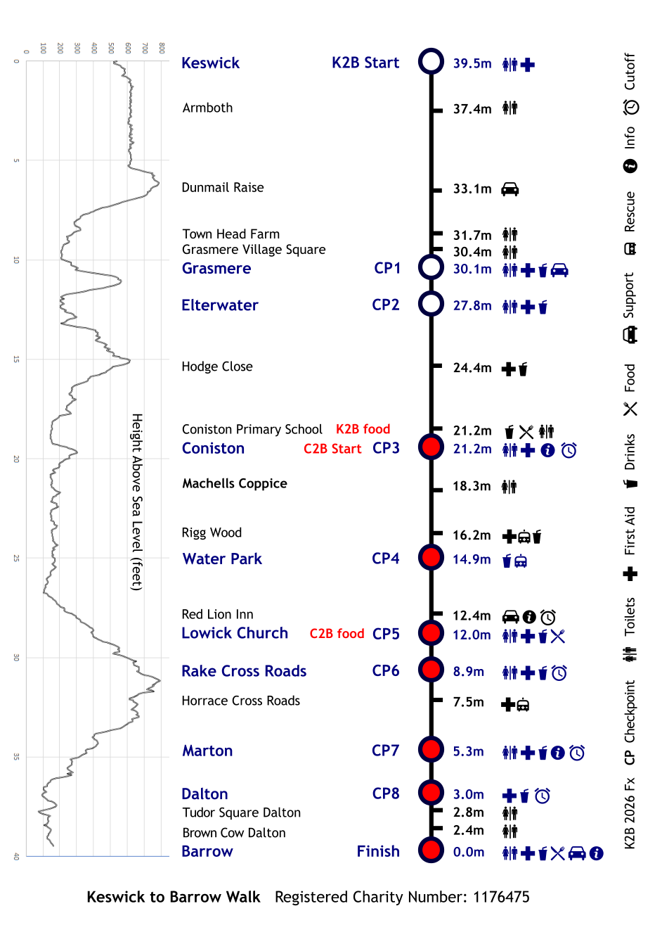
Route description
Route descriptionLast updated on 7th April 2026: Coniston Start arrangements.
We have been advised that our preferred K2B walk route, starting at Legburthwaite and proceeding down the west of Thirlmere, is available for the 2026 walk.
The Team Support Handbook contains information which should help you to understand the key safety aspects of the walk. Much of the walk takes place on public roads which are open to traffic, so participants must be sensible and obey the Highway Code. Please be considerate to residents and local businesses. Respect the countryside, and dispose of litter responsibly in the sacks and bins provided. Instructions relating to support vehicles have been prepared with the help of Cumbria Constabulary. Some sections of the route are closed to all vehicles, except for emergency services and official vehicles driven by the event organisers. Support vehicle drivers must not attempt to enter these sections of the route, and must obey "No entry" signs and "No support vehicles" signs. Support vehicles are not permitted at any of the following locations:
- A591 north of Dunmail Raise
- Elterwater village
- Little Langdale
- Tilberthwaite
- Hodge Close
- Shepherds Bridge Lane in Coniston village
- Coniston Sports & Social Centre
- The road east of Coniston Water
- Kirkby Moor (west of Lowick)
- Marton village
- Broughton Road between the Black Dog Inn and the northern outskirts of Dalton
- Hawcoat Park Sports Club
The walk has a low accident record, and with your support, we aim to keep it that way. The support vehicle routes are aimed at minimising congestion on the walk route, some parts of which are very narrow and potentially hazardous. Please follow instructions from the walk marshals, who will be in attendance on motorbikes and on foot. Marshals are instructed to note the registration numbers of any vehicles that cause a nuisance, to be dealt with appropriately by the authorities.
The aerial views and maps are courtesy of Google Earth and Google Maps.
Download the route: GPX file
Your dog may accompany you on the walk if you consider that it is fit to do so. The organisers do not provide veterinary or other support services for dogs. Dogs (except guide dogs) are NOT permitted on Happy Buses, or in the field immediately to the south of Coniston Sports Club.
Make sure that you pay to park in any car parks where charges apply, even if you're only there for a short time.
In an emergency phone 999 and then 0777 888 4020
In an emergency when violence or a threat to life is posed, a crime is in progress, or a serious accident has occurred, always dial 999. Please then call the event incident support (ICE) number as soon as possible on 0777 888 4020.
K2B Start (Walkers)
K2B Start (Walkers)Legburthwaite
- Miles to go: 39.5
The 2025 start is at Legburthwaite, close to the northern end of Thirlmere, on the east side. There is very limited capacity for drop-off in the start area, and no space for parking vehicles, so all walkers are strongly encouraged to use the Happy Buses to get there. If you plan to arrive in your own car, please follow the support vehicle instructions on the following page.
- Support vehicle drop off (no parking)
- Toilets - at the walker assembly area
SAFETY: There will be many walkers, and some moving vehicles in the start area. Stay alert, and pay attention to instructions from marshals. Once you've crossed the start line, walk at a pace that comes naturally. If you go either above or below your natural pace you’ll tire far more rapidly, both physically and mentally. While it’s good to journey with other walkers, you should ensure that their pace is close to yours. Completing the walk safely is much more important than a fast time. Many problems can be avoided by taking just a little longer, and allowing time for eating sugary/salty snacks at support points, drinking plenty of fluids, and tending minor injuries. Good luck!
K2B Start (Vehicles)
K2B Start (Vehicles)
Dunmail Raise (Support)
Dunmail Raise (Support)
Dunmail Raise northbound carriageway
- Miles to go: 33.08
Dunmail Raise on the A591 is well known as an area that was badly affected by the December 2015 floods. It lies between the southern end of Thirlmere, and Grasmere village. The K2B walk route follows the cycleway from Steel End at the south end of Thirlmere, to the dual carriageway at Dunmail Raise.
- Support vehicle parking - at the roadside on Dunmail Raise
- Toilets - at Townhead Farm (1.4 miles south of Dunmail Raise)
This is where you have your first opportunity to meet your support vehicles. From here continue south along the A591 down Dunmail Raise, turning right at the first opportunity. Continue via Gill Foot and Goody Bridge to the quaint village of Grasmere. Turn right into the village square (Toilets) where marshals will guide you to the village car park.
INTERESTING FACT: A cairn at Dunmail Raise marks the spot of a great battle between the Norse king, Dunmail of Cumbria, and the Anglo-Saxon king, Edmund of Northumbria, in 945AD. Edmund's victory meant that the north-western area of Cumbria passed over to the Scots. The cairn also marks the boundary between the old counties of Cumberland and Westmorland.
Dunmail Raise (Vehicles)
Dunmail Raise (Vehicles)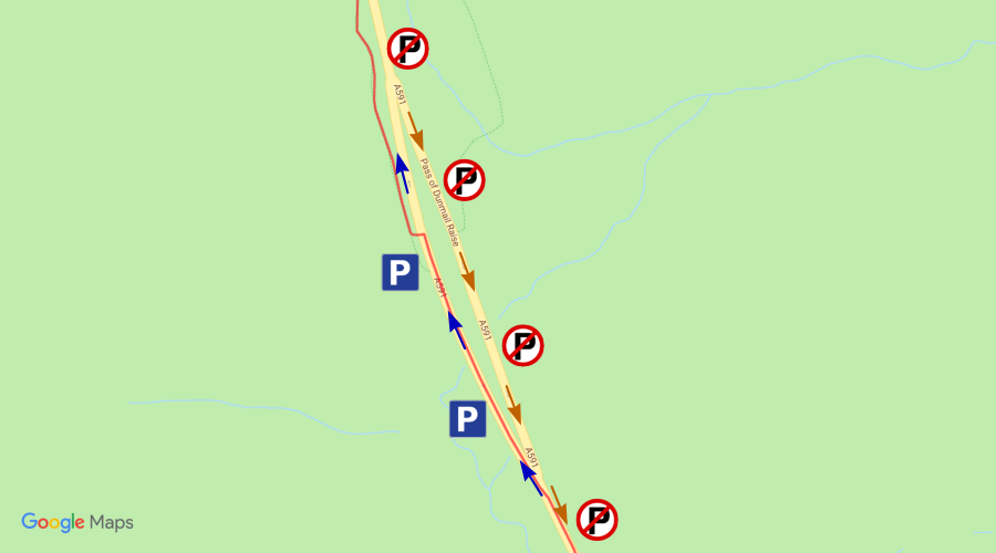
- OS Grid Ref: NY 327 117
- Nearest postcode: CA12 4TP
- Follow blue arrows when arriving, brown arrows when leaving.
Parking is available on northern carriageway of the dual carriageway section. The southbound carriageway will be operated as a contra-flow, and parking is not permitted on that side. Please follow local instructions for parking and guidance from marshals.
Users of the car parking area do so at their own risk. The organisers will not accept responsibility for damage, accident or loss.
Grasmere (CP1)
Grasmere (CP1)
Red Bank Road car park
- Miles to go: 29.92
The first official timing checkpoint is a Grasmere. Remember to tap your tag on the reader.
- Toilets – village square (before the Checkpoint)
- Drinks provided – at Checkpoint
- First Aid – at Checkpoint
- Support vehicle parking - Stock Lane car park (pay & display)
Support vehicle drivers are responsible for their own parking charges, and for payment of any fines incurred for non-payment. READ MORE
From Grasmere continue in the direction of Elterwater where you will come across the notorious Red Bank, this is a rather steep hill so take it easy. From the top of Red Bank continue to follow route signs which direct you down the wiggly road to Elterwater Common (enjoy the view) and on to Elterwater village.
INTERESTING FACT: Grasmere village is a classic tourist attraction. Here is Dove Cottage, the home of the English poet William Wordsworth. Sir Walter Scott often visited the Wordsworths, and is also known to have frequented The Swan Hotel, where he partook of a few drams. Grasmere is now the home of Sarah Nelson’s world-famous Grasmere Gingerbread shop, which is tucked away at the corner of the churchyard of St. Oswald’s Church.
Grasmere (Vehicles)
Grasmere (Vehicles)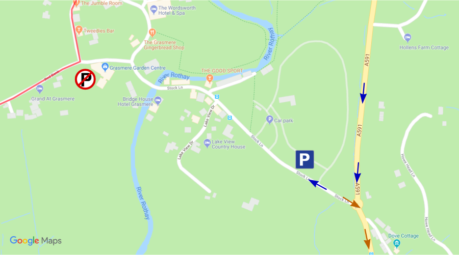
- OS Grid Ref: NY 340 071
- Nearest postcode: LA22 9SH
- Follow blue arrows when arriving, brown arrows when leaving.
The Grasmere checkpoint is located in a car park which has limited spaces and gets very congested. Please park in the large car park on the right of Stock Lane, just after the turn off from the A591. It has public toilets and is only a few minutes walk from the checkpoint.
Users of the car parks do so at their own risk. The organisers will not accept responsibility for damage, accident or loss.
DO NOT FOLLOW THE WALK ROUTE to ELTERWATER.
Elterwater, Little Langdale, Tilberthwaite, and Hodge Close are closed to support vehicles, and this will be enforced by police.
GRASMERE IS THE LAST SUPPORT POINT BEFORE CONISTON CP3.
Follow the A591 to Ambleside, and then the A593 directly to Coniston.
Elterwater (CP2)
Elterwater (CP2)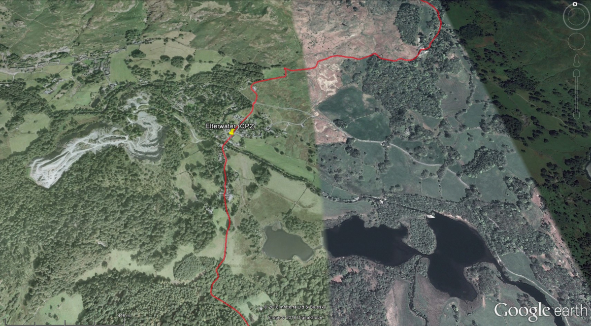
Britannia Inn
- Miles to go: 27.24
Over a third of the walk distance is complete at this point. The checkpoint is positioned outside the Britannia Inn.
- Toilets – at Checkpoint
- Drinks – at Checkpoint
- First Aid – at Checkpoint
- No support vehicles
Leave Elterwater heading southwards, towards Colwith. Then you'll follow the longest off-road section of the K2B route, via Stang End and Hodge Close, down to Yewdale.
- First Aid - Hodge Close
- Drinks - Hodge Close
- No support vehicles
Elterwater, Little Langdale, Tilberthwaite, and Hodge Close are closed to support vehicles, and this will be enforced by police.
Continue to the edge of Coniston village, where you'll leave the track and head down towards Shepherds Bridge Lane. Checkpoint 3, toilets and food for K2B walkers are at Coniston Primary School, on the right-hand side of the lane as you head down. After leaving Checkpoint 3, you'll continue southwards via Coniston Sports & Social Club, and then east towards Monk Coniston.
INTERESTING FACT: Elterwater village lies in the jaws of the Great Langdale valley. From the 1750's, the local green slate was in high demand. To service the quarries, a great deal of gunpowder was needed. For this reason, many juniper trees were planted in the area. Juniper wood makes excellent charcoal, a major base-ingredient of gunpowder.
Coniston (CP3)
Coniston (CP3)
Coniston Primary School
- Miles to go: 21.2
This checkpoint is at Coniston Primary School in Shepherds Bridge Lane. Support vehicle parking is available in Coniston village, subject to payment if required.
- Food and drinks for K2B walkers - at Coniston Primary School
- Toilets – at the Checkpoint
- First Aid – at the Checkpoint
Well behaved dogs on leads are permitted on the hard-surface areas at Coniston Primary School (C2B start and K2B food point), but please keep them off the grass and clear up any mess.
This is the last point where your support crews can meet you before Lowick. (Support vehicles must travel via Torver to Lowick).
The walk route continues via Coniston Sports & Social Club, and then crosses a privately owned field, which may be in use for lambing. Please walk through it responsibly, staying within the marked area close to the field boundary, and avoid upsetting the sheep. If you have a dog, please register at Checkpoint 3 as normal, and you MAY be asked to take a short detour to the bottom of Shepherds Bridge Lane, turn left at the junction and walk over the stone bridge, taking care to avoid traffic on the road. Rejoin the main walk route on the footpath on the left of the road beyond the small cluster of houses.
Coniston Primary School is our central control point, so please visit us here if you need information about the progress of walkers, to report incidents, etc. The dedicated phone number for the C2B Walk team is 07484 200700.
Designated official event vehicles will assist walkers if necessary between Monk Coniston and Lowick.
INTERESTING FACT: Using the proceeds from her book sales, Beatrix Potter acquired nearly 7,000 acres of land in the Lake District, including the Monk Coniston Estate, all of which she transferred or bequeathed to the National Trust.
Coniston (Vehicles)
Coniston (Vehicles)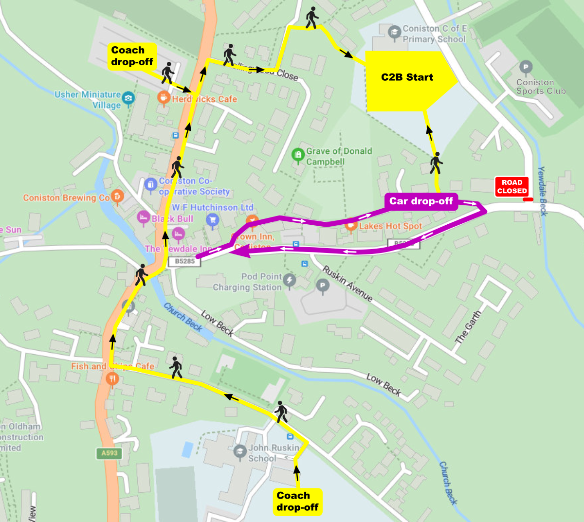
- OS Grid Ref: SD 302 973
- Nearest postcode: LA21 8EW
Shepherds Bridge Lane will be closed to traffic, from the A593 at its north end, to the B5285 at its south end. Support vehicles should park in one of the Coniston village car parks and pay the appropriate parking fee. There is no free parking for support vehicles in Coniston.
Please approach Coniston via the A593 from the north or south. When leaving Coniston, support vehicles should return to the A593, and follow the road towards Torver, and the next support car park at Lowick Bridge.
Limited car parking is available at Coniston Sports Club for disabled blue badge holders only.
There are no official support or parking areas on the B5285 or at Monk Coniston. Do not drive along or park on the B5285, or on Tilberthwaite Avenue at the junction with Shepherds Bridge Lane, as this is a bus route and parking on the road can cause congestion and safety issues. Support vehicles MUST NOT use the road to the east of the lake, between Monk Coniston and Lowick Bridge. There is a Lake District National Park (LDNP) Authority pay and display car park at Monk Coniston. K2B marshals will be supervising walkers on the road, but they have no responsibility for the car park.
C2B Start (Walkers)
C2B Start (Walkers)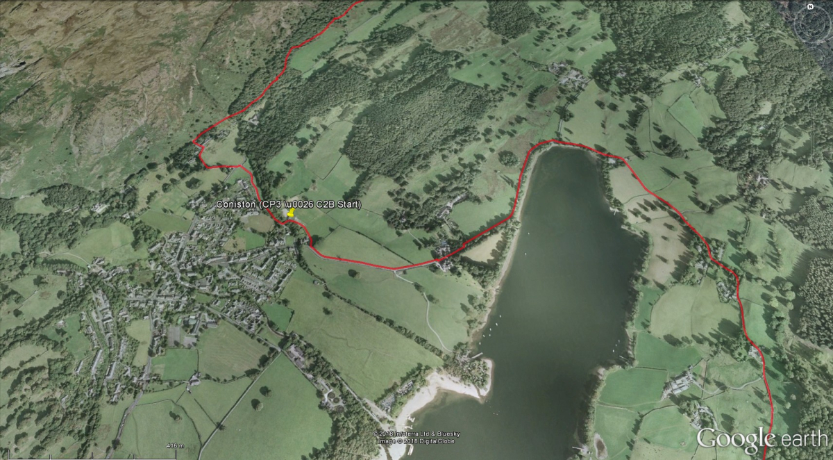
Coniston Primary School
- Miles to go: 21.2
The Coniston to Barrow Walk (C2B) starts on the edge of Coniston village at Coniston Primary School in Shepherds Bridge Lane.
Participants arriving on an official Happy Bus will be dropped off at one of several locations in Coniston village, and will be guided to the start by marshals.
- Toilets - at the walker assembly area
The C2B walk starts in the grounds to the south of Coniston Primary School. There is a large number of people to be accommodated, so it is essential that you pay close attention to instructions from marshals, and listen carefully to information provided.
Well behaved dogs on leads are permitted on the hard-surface areas at Coniston Primary School (C2B start and K2B food point), but please keep them off the grass and clear up any mess.
Shortly after the start of the C2B walk, walkers cross a small field and exit via a farm gate onto the public footpath alongside the B5285. The field may be in use for lambing. Please walk through it responsibly, staying within the marked area close to the field boundary, and avoid upsetting the sheep. If you have a dog, please register at the C2B start checkpoint, where you MAY be asked to take a short detour to the bottom of Shepherds Bridge Lane, turn left at the junction and walk over the stone bridge, taking care to avoid traffic on the road. Rejoin the main walk route on the footpath on the left of the road beyond the small cluster of houses.
The walk proceeds eastwards along the footpath, across the top end of Coniston Water, and then down the east side of the lake.
C2B Start (Vehicles)
C2B Start (Vehicles)
- OS Grid Ref: SD 302 973
- Nearest postcode: LA21 8EW
Shepherds Bridge Lane will be closed to all traffic except for event organisers, blue badge holders, and emergency services. The walker drop-off point for those arriving by car is at Hawkshead Old Road. Drivers, please enter Hawkshead Old Road from the Crown Inn end, and drive eastwards, as shown above in purple.
Walkers arriving by coach will be dropped off either at John Ruskin School, or at the Blue Bird car park (next to Herdwicks Cafe). Walking routes from those locations to the C2B Start are shown above in yellow.
Car parking is available at Coniston Sports Club for disabled blue badge holders only. Enter the southern end of Shepherds Bridge Lane via the A5285, and drive slowly northwards to the club entrance. You MUST drive carefully, and follow instructions from marshals. Park in the sports club car park where directed by marshals. Inform the marshals before attempting to leave the sports club, and await permission to leave. You may then follow the A593 towards Torver, and the next support car park at Lowick Bridge.
There are no official support parking areas on the B5285 or at Monk Coniston. Do not stop on the B5285, especially at the junction with Shepherds Bridge Lane, as this is a bus route. Support vehicles MUST NOT use the road to the east of the lake, between Monk Coniston and Lowick Bridge.
Rigg Wood (First Aid)
Rigg Wood (First Aid)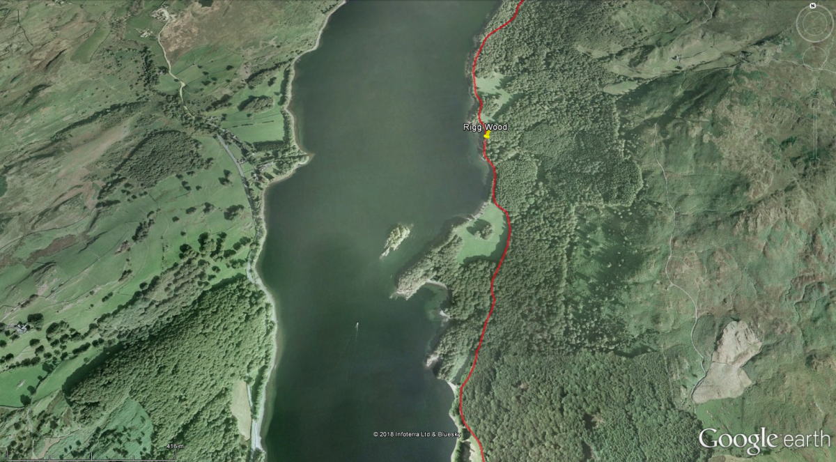
Rigg Wood
- Miles to go: 16.22
The wood is on the left side of the road as you continue down towards Water Park.
- First Aid - at Rigg Wood
- No support vehicles
INTERESTING FACT: Rigg Wood is privately owned, but is open to the public for walking. It is adjacent to Grizedale Forest, a 6,050-acre (2,447 hectare) forest managed by the Forestry Commission, visited by 200,000 people each year. Fans of Arthur Ransome's Swallows and Amazons series visit Rigg Wood to see the ruin of a traditional circular stone hut, believed to have been the inspiration for an "igloo" described in the book "Winter Holiday".
Water Park (CP4)
Water Park (CP4)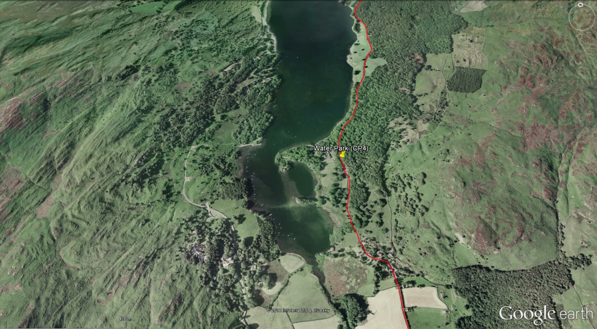
Water Park layby
- Miles to go: 14.85
The checkpoint is by the roadside at Water Park Adventure Centre.
- Drinks - at Checkpoint
- No support vehicles
From here you continue down the east side of Coniston Water for several miles past the edges of Grizedale Forest, and through the village of Nibthwaite. Then on to Lowick and the temptation of the Red Lion Inn.
INTERESTING FACT: Look to your right as you walk through Nibthwaite. Just behind a farm gate, you may spot an Antony Gormley life-size figure, looking out over Coniston Water. Apparently, Antony Gormley is a frequent visitor to the area.
Lowick Bridge (Information)
Lowick Bridge (Information)
Red Lion Inn
- Miles to go: 12.39
Lowick provides the first opportunity since Coniston to meet up with your support crew.
- Support vehicle parking – field near the Red Lion Inn
- Toilets – at the Red Lion Inn
Walkers who reach the Red Lion Inn at Lowick Bridge after 4:00pm will be stopped at this point, for their own protection, and to safeguard the volunteer marshals further down the route. This is non-negotiable. Transport will be provided to the finish.
INTERESTING FACT: Every May Bank Holiday one household in Lowick village hosts a 'duck race', whereby plastic ducks are put into the stream in the house's garden and 'raced' against each other. In 2002 a competitor was disqualified when it was discovered that he had greased his ducks with lard in order to speed their progress.
Lowick Bridge (Vehicles)
Lowick Bridge (Vehicles)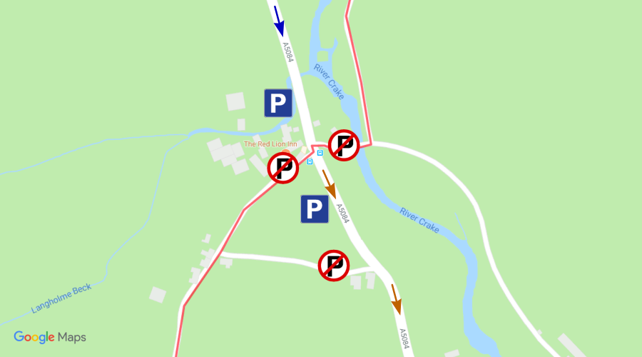
- OS Grid Ref: SD 292 865
- Nearest postcode: LA12 8EF
- Follow blue arrows when arriving, brown arrows when leaving.
There is a field at Lowick Bridge for support vehicle parking. Please park sensibly in the field or on the roadside verges, and don’t block gateways, side roads, etc.
Users of the car park do so at their own risk. The organisers will not accept responsibility for damage, accident or loss.
THE LOWICK JUNCTION WILL BE POLICE CONTROLLED. ANY OBSTRUCTION OR PARKING WHERE THERE ARE POLICE RESTRICTIONS WILL RESULT IN A POSSIBLE PARKING TICKET.
DO NOT FOLLOW THE WALK ROUTE “OVER THE TOP” OF KIRKBY MOOR.
From Lowick proceed on the main road (A5084/A590) via Greenodd and on to Ulverston. A “PICK UP POINT” is available at Horrace cross roads. Make your way up on to Kirkby Moor and intersect the route ONLY IF YOU REQUIRE TO PICK UP A RETIREE.
From Ulverston you can proceed via the A590 to Tarn Flatt, south of the village of Marton to rejoin the walk route. It is appreciated that the walk route from Lowick “over the top” to Marton is particularly arduous and again an official support vehicle has been arranged. This will vehicle collect the lame and take them to the Marton checkpoint, or, if necessary, the First Aid post at the Black Dog junction.
Lowick Church (CP5 & C2B food)
Lowick Church (CP5 & C2B food)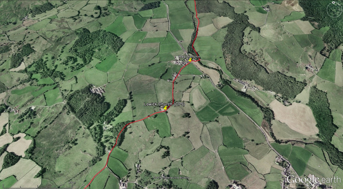
Lowick Church Hall and car park
- Miles to go: 12.04
Support is provided at Lowick Church, a third of a mile further up the route from the Red Lion. Food is provided here for C2B walkers, who are approaching the half-way point of the C2B route.
- Toilets - at Checkpoint
- Drinks - at Checkpoint
- Food - at Checkpoint for C2B only
- First Aid - at Checkpoint
- No support vehicles
The challenge now starts to get interesting as you face a four-mile steady up hill climb to the route’s highest point on Kirkby Moor. Support vehicles are not permitted along this stretch of the route.
Rake Cross Roads (CP6)
Rake Cross Roads (CP6)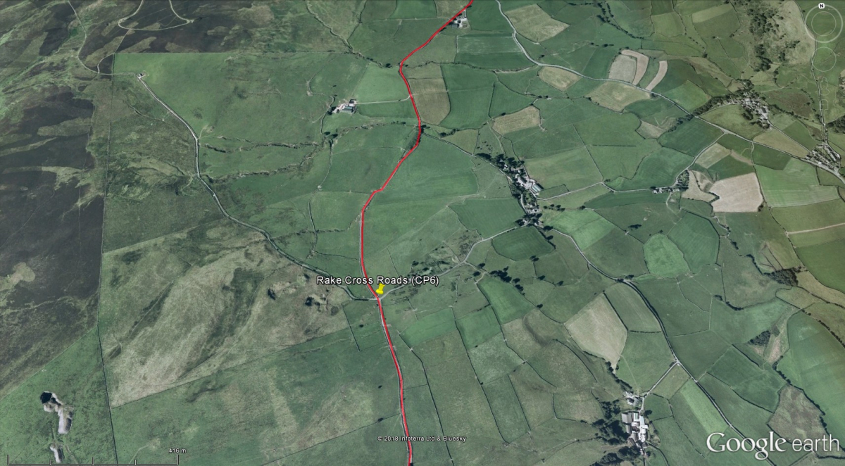
Rake Cross Roads
- Miles to go: 8.90
The emergence of the wind turbines on the top of the moor indicates you are approaching the summit and Rake Cross Roads Checkpoint gives you an opportunity to rest prior to attempting the final half mile of ascent.
- Toilets – at Checkpoint
- Drinks – at Checkpoint
- First Aid – at Checkpoint
- No support vehicles
Walkers who reach Rake Cross Roads after 6:00pm will be stopped at this point, for their own protection, and to safeguard the volunteer marshals further down the route. This is non-negotiable. Transport will be provided to the finish.
As you approach the top of the moor the views can be fantastic. Behind you are the peaks of the Lake District, many some 30 miles into the distance where you started your trek.
Horrace (Pick up)
Horrace (Pick up)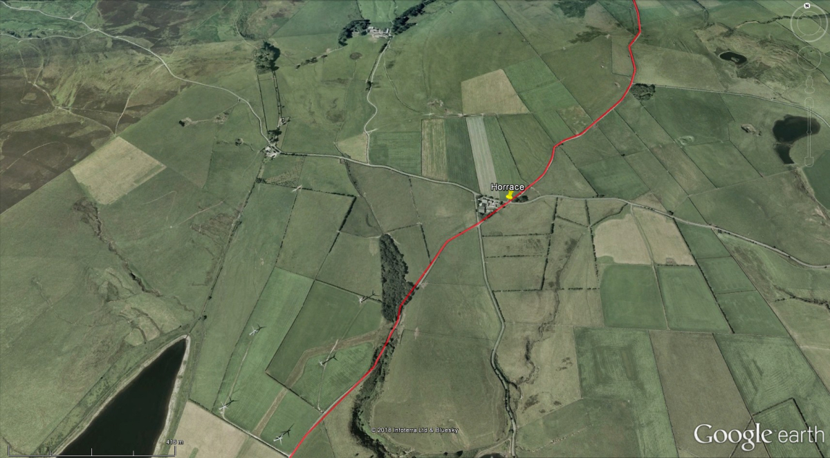
Horrace Farm
- Miles to go: 7.53
At this point you are now on top of the Moor and is the first opportunity to provide support to your team since Lowick. There is very limited parking for support vehicles, so this point should only be used by support crews to pick up tired or injured walkers who are dropping out of the walk.
- First Aid - at Horrace
- Support vehicles only for collecting dropouts
INTERESTING FACT: As you proceed along the moor, Morecambe Bay can be viewed to the left with Blackpool and the Pennines beyond. To the right is the Duddon Estuary, the Irish Sea and the Isle of Man (Ireland and Wales can also be seen on a clear day). Ahead is the Furness peninsula and the islands surrounding the port of Barrow. The fictional Island of Sodor in the Thomas the Tank Engine stories was based on an amalgamation of Walney Island and the Isle of Man.
Horrace (Vehicles)
Horrace (Vehicles)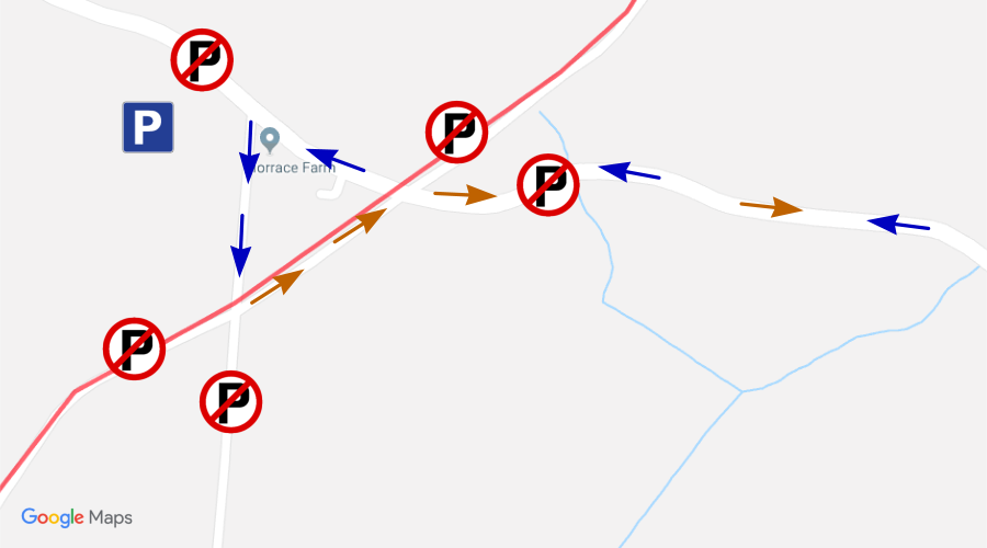
- OS Grid Ref: SD 260 800
- Nearest postcode: LA12 7SB
- Follow blue arrows when arriving, brown arrows when leaving.
PICK UP POINT ONLY - DO NOT DRIVE THE WALK ROUTE.
The walk route over the moor is fully supported by First Aid and an Emergency Rescue vehicle. Please use this support point only if absolutely essential.
Access to Horrace is via Daltongate and Stockbridge Lane in Ulverston. Approach Horrace with great caution as walkers will be crossing the road. Follow the direction of the blue arrows on the above map.
There is very limited parking available. Please park where instructed by marshals. DO NOT PARK on the main Ulverston road.
Users of the car parking area do so at their own risk. The organisers will not accept responsibility for damage, accident or loss.
Leave the area following the route indicated by the brown arrows on the map.
Marton (CP7)
Marton (CP7)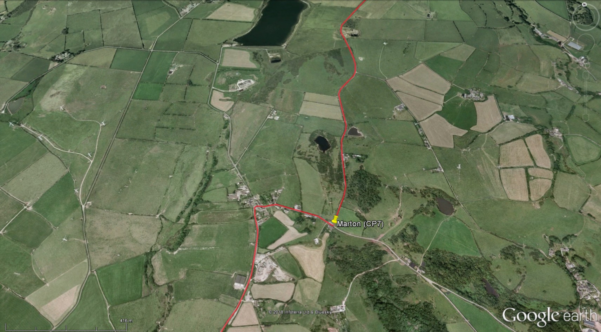
Snipe Ghyll
- Miles to go: 5.25
As you start your descent into the Lower Furness area you will reach the rural village of Marton, where you will find the checkpoint at the foot of Snipe Ghyll.
- Drinks - at Checkpoint
- First Aid - at Checkpoint
- Toilets - at Checkpoint
- Support vehicle parking - Tarn Flatt (about a mile after the Checkpoint)
Walkers who reach Marton after 7:00pm will be stopped at this point, for their own protection, and to safeguard the volunteer marshals further down the route. This is non-negotiable. Transport will be provided to the finish.
Turn right, and carry on through the village towards Tarn Flatt. Continue southwards and via the Black Dog Inn junction towards Dalton.
INTERESTING FACT: The Marton War Memorial is almost identical to the Lindal War Memorial. Both are carved from Stainton limestone, and carry the names of those from the villages who lost their lives whilst serving in the First World War.
Marton (Vehicles)
Marton (Vehicles)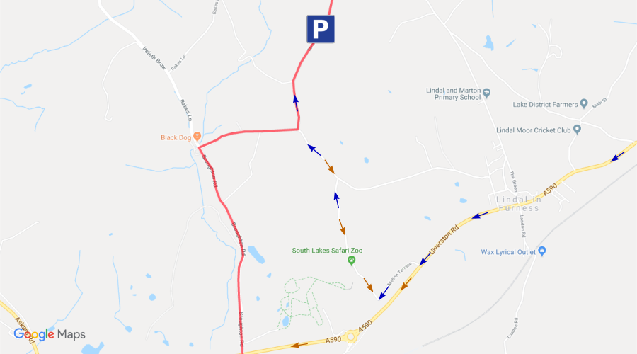
- OS Grid Ref: SD 238 761
- Nearest postcode: LA15 8JW
- Follow blue arrows when arriving, brown arrows when leaving.
Approach via the A590 junction at Melton Brow, signposted for the Safari Zoo. Continue past the zoo entrance, turn left at the end of the road, and then first right.
On the south side of Marton village, the Tarn Flatt road is available for parking. Please do not block residential access or field gates.
Users of the car parking area do so at their own risk. The organisers will not accept responsibility for damage, accident or loss.
The roads are narrow and will be busy with walkers, so drive with caution at all times. Driving through Marton village is prohibited.
BROUGHTON ROAD WILL BE CLOSED FROM THE NORTH OF DALTON TO THE BLACK DOG INN JUNCTION. ACCESS ONLY TO RESIDENTS.
Return to the A590 via the same route as for your arrival. Please be considerate to residents, and traffic trying to exit the zoo.
Dalton (CP8)
Dalton (CP8)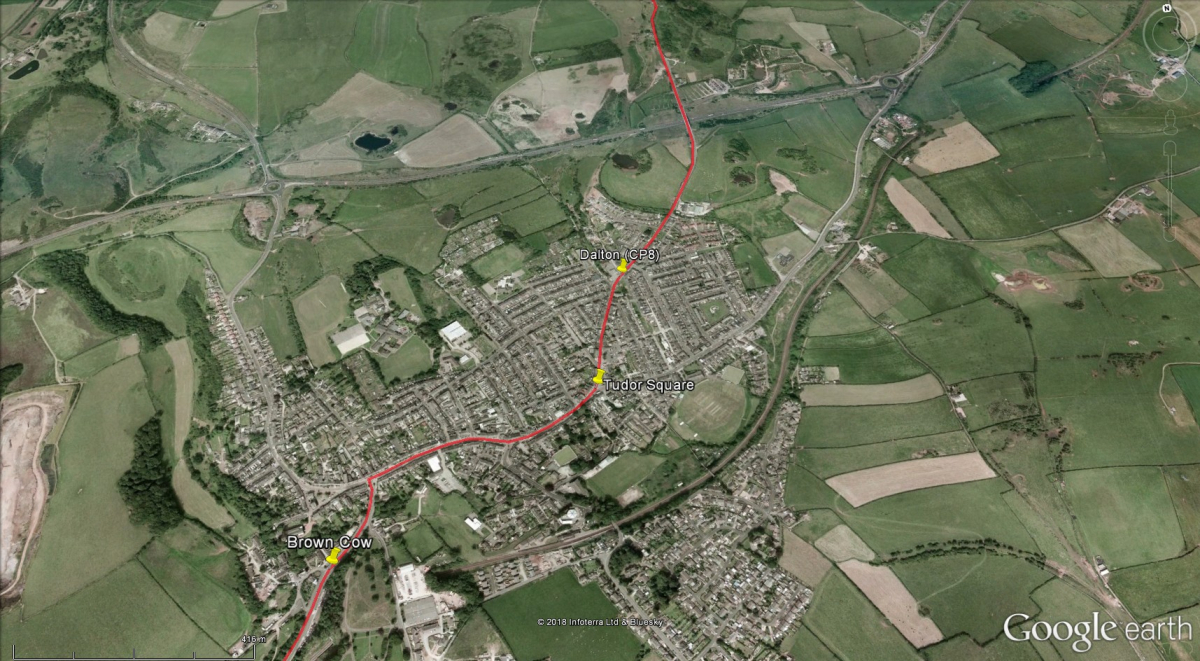
Broughton Road
- Miles to go: 2.99
The ancient capital of Furness makes for the last – and much appreciated stop. The checkpoint is opposite the old fire station (now houses) in a grassy space on the edge of the town. There is limited car parking in this area.
- Drinks – at Checkpoint
- First Aid – at Checkpoint
- Toilets – 200m past the Checkpoint at Tudor Square
Walkers who reach Dalton after 8:00pm will be stopped at this point, for their own protection, and to safeguard the volunteer marshals further down the route. This is non-negotiable. Transport will be provided to the finish.
Proceed through Dalton, turning right at Tudor Square, and then turning left at the White Horse Inn junction. Keep to the left-hand pavement as you walk down the hill, and continue on the left-hand pavement all the way to the Abbey House Hotel, until directed by police and/or marshals to cross Abbey Road. The last mile can be the toughest of them all. No stopping now though.
- Drinks - Brown Cow
- Toilets - Brown Cow
- Drinks - Stone Trough, Abbey Road
INTERESTING FACT: One of Dalton's most famous sons was George Romney, who was a talented 18th century high-society portrait painter. He was also a keen scientist, and spent much time practising the art of alchemy (aiming to turn cheap base metals into valuable metals such as gold) with his friend Williamson, a Dalton watchmaker. However, this pursuit came to an abrupt halt when they accidentally blew up their furnace.
Barrow (Finish)
Barrow (Finish)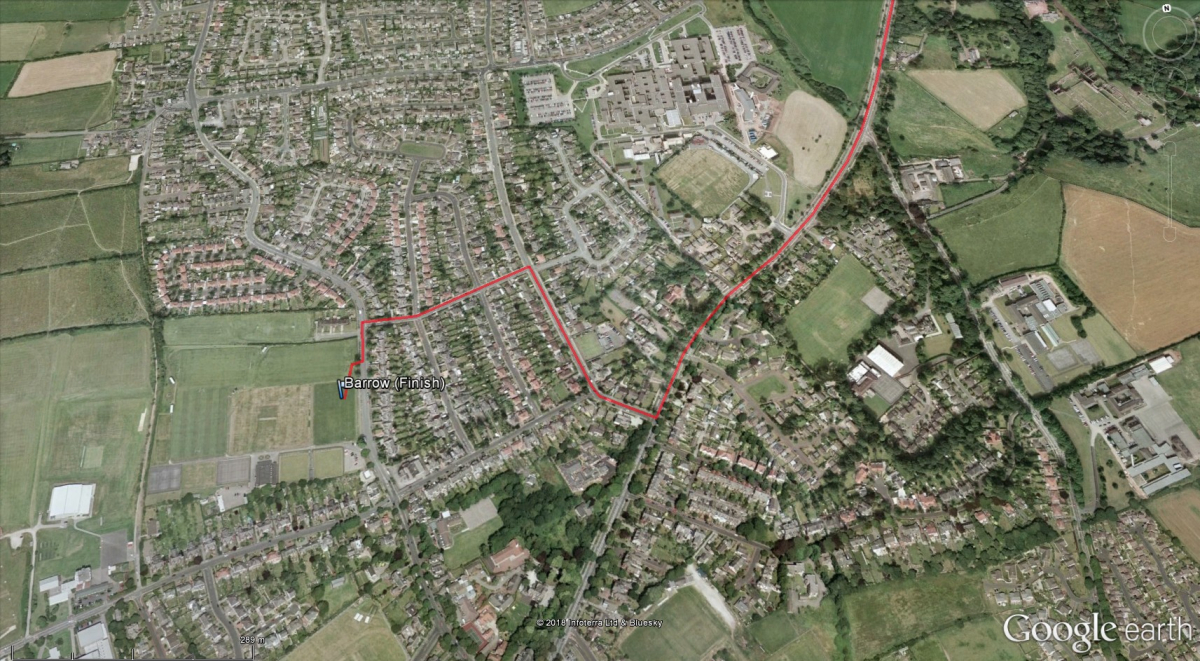
Hawcoat Park Sports Club
- Miles to go: 0.00
The finish is on the outskirts of Barrow at Hawcoat Park Sports Club on Hawcoat Lane. This is accessed by turning right off Abbey Road at the Glen Garth Hotel. Proceed up Dane Avenue to Hartland Road where you turn left and continue on to Hawcoat Lane, and the finish will be in sight. As you arrive you will be applauded by well-wishers and many other participants with mutual respect for what you have accomplished. Settle down in the club, enjoy your free drinks and soak in the tremendous atmosphere.
- First Aid - in the finish tent
- Toilets - in the sports club building
- Changing facilities & showers - in the sports club building
- Food & drinks vouchers are given to all participants
- Parking - in the surrounding roads and also Hoops (sports centre) car park on Thorncliffe Road
INTERESTING FACT: Hawcoat Park Sports Club is an independent "Community Amateur Sports Club", which is owned and managed by its members. It is still known by the local taxi drivers as "Vickers Sports Club", as it was originally operated exclusively for employees of the Barrow shipyard, but this is no longer the case. The club supports a wide range of sports activities and teams, including rugby union, football, cricket, tennis, crown green bowling, shooting, archery, tennis, and table tennis. There are many music and sporting events throughout the year. Indoor and outdoor facilities are available for private hire, and are popular for charity fundraising events, conferences, weddings, and funerals! Membership is open to all.
Barrow (Vehicles)
Barrow (Vehicles)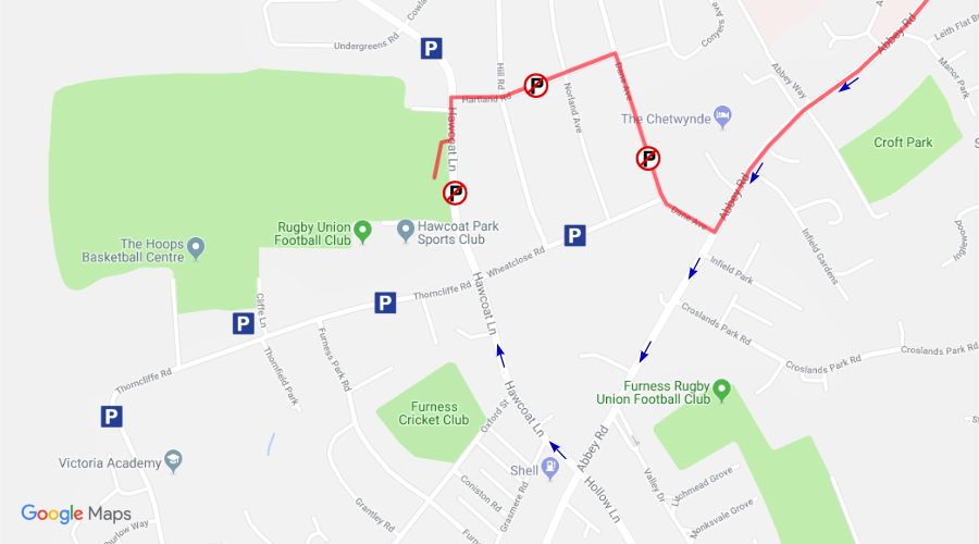
- OS Grid Ref: SD 205 713
- Nearest postcode: LA14 4HF
- Follow blue arrows when arriving.
Hawcoat Park Sports Club,
Hawcoat Lane,
Barrow-in-Furness,
Cumbria,
LA14 4HF.
The blue "P" signs on the above map are indicative only, and represent roadside parking areas.
Please do not park on Hawcoat Lane alongside the Sport Club. Limited parking is available in the Hoops car park off Thorncliffe Road.
Do not park on the walk route. Car parking at the sports club is reserved for event pass holders only.
Unfortunately, parking in this area can be quite difficult at peak times, so be prepared to park further away than you would ideally like, and walk to the sports club.
Users of the car parking areas do so at their own risk. The organisers will not accept responsibility for damage, accident or loss.
Simple route map
Simple route mapThe K2B walk starts at Legburthwaite and follows a path on the west of Thirlmere, and then via Grasmere, Elterwater, and Hodge Close, to Coniston. The C2B walk starts at Coniston Primary School, and both walks then follow the same route via the east of Coniston, and via Lowick, Marton, and Dalton, to Hawcoat Park Sports Club in Barrow.